- Gathering Information on Tsunamis and Storm Surges Using Live Cameras
- Tsunamis Occurring on the Pacific Coast of Hokkaido and Tohoku Regions
- Tsunamis Occurring in the Kanto Region
- Tsunamis Occurring in the Sea of Japan
- View of the Sea of Japan from Nabetsuru Rock on Okushiri Island (Hokkaido)
- View of Ishikari Bay from Tenguyama in Otaru (Hokkaido)
- View of the Sea of Japan from Akita Port (Akita Prefecture)
- View of the Sea of Japan from Sakata Port (Yamagata Prefecture)
- View of the Sea of Japan from the mouth of the Shinano River (Niigata Prefecture)
- View of the Sea of Japan from Himi City (Toyama Prefecture)
- View of the Sea of Japan from Wajima on the Noto Peninsula (Ishikawa Prefecture)
- View of the Sea of Japan from Echizen Town (Fukui Prefecture)
- View of the Sea of Japan from Fushino Coast in Tottori City (Tottori Prefecture)
- View of the Sea of Japan from Oki Islands (Shimane Prefecture)
- View of the Sea of Japan from Tsunoshima Bridge (Yamaguchi Prefecture)
- View of Genkai Sea from Hatsu Coast in Okagaki Town (Fukuoka Prefecture)
- Tsunamis Generated by the Nankai Trough
- Izu Shirahama Beach (Shizuoka Prefecture)
- Chubu Centrair International Airport (Aichi Prefecture)
- Minamiise Town (Mie Prefecture)
- Tenjinzaki (Wakayama Prefecture)
- Osaka Port (Osaka Prefecture)
- Akashi Kaikyo Bridge (Hyogo Prefecture)
- Miyajima Itsukushima Shrine (Hiroshima Prefecture)
- Naruto Bridge (Tokushima Prefecture)
- Seto Ohashi Bridge (Kagawa Prefecture)
- Sanport Takamatsu (Kagawa Prefecture)
- Chichibugahama Beach (Kagawa Prefecture)
- Shimanami Kaido (Ehime Prefecture)
- Uwajima City (Ehime Prefecture)
- Beppu Onsen (Oita Prefecture)
Gathering Information on Tsunamis and Storm Surges Using Live Cameras
Numerous live cameras are installed along Japan’s coastline, capturing images of beaches, coastlines, and ports. These live cameras are essential tools for real-time monitoring of storm surges and tsunamis. Storm surges are caused by typhoons and explosive cyclones, which have been increasing in size and intensity due to global warming. Therefore, coastal areas where tidal levels rise significantly due to geographical factors, such as bays, are at higher risk of storm surges.
On the other hand, tsunamis are natural disasters that can occur anywhere in Japan. Their destructive power is immense, and their unpredictability adds to their terror. Tsunamis travel at an astonishing speed of over 800 km/h and possess enormous energy capable of easily sweeping away buildings and vehicles upon reaching land. Recent examples of tsunami damage include the Great East Japan Earthquake in March 2011 and the Noto Peninsula Earthquake in January 2024. Additionally, the earthquake off the coast of Miyazaki Prefecture in August 2024, although resulting in a small tsunami, led to the first issuance of the “Nankai Trough Earthquake Temporary Information” by the Japan Meteorological Agency. If a massive Nankai Trough earthquake occurs, some areas from Shizuoka Prefecture to Miyazaki Prefecture are expected to experience seismic intensity 7, and a massive tsunami exceeding 10 meters could strike a wide range of the Pacific coast from the Kanto region to the Kyushu region.
Furthermore, tsunamis can be triggered not only by earthquakes but also by meteorological phenomena and submarine volcanic eruptions, making their mechanisms of occurrence diverse. Therefore, it is crucial to correctly understand the types of tsunami risks present in your area, including their background.
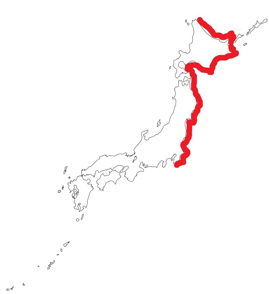
Tsunamis Occurring on the Pacific Coast of Hokkaido and Tohoku Regions
Along the Japan Trench (off the coast of Boso to east of Aomori Prefecture) and the Kuril Trench (off Tokachi to the Kuril Islands), M7 to M9 class earthquakes frequently occur, causing significant damage. The Tokachi-Oki Earthquakes in Hokkaido in 1952 and 1968 both generated tsunamis, causing damage to the coastal areas of the Pacific side of Hokkaido.
The Pacific coast of the Tohoku region has also experienced significant tsunami threats, such as the Meiji Sanriku Earthquake in 1896, the Showa Sanriku Earthquake in 1933, and the more recent Great East Japan Earthquake in 2011. The Great East Japan Earthquake on March 11, 2011, triggered by a massive M9.0 earthquake, brought an unprecedented tsunami reaching up to 40.5 meters, devastating the Pacific coast of the Tohoku region. This unprecedented disaster claimed over 20,000 lives and caused extensive damage to the society and economy of the Tohoku region.
In response to this lesson, live cameras installed along the coast of the Tohoku region capture abnormal wave movements and tidal levels in real-time, functioning as part of an early warning system. Additionally, the Great East Japan Earthquake caused severe damage to the Fukushima Daiichi Nuclear Power Plant due to the tsunami, resulting in a serious meltdown. Recovery work is ongoing, but it is essential to continuously address the tsunami risk. The live cameras allow real-time monitoring of the sea conditions around the Fukushima Daiichi Nuclear Power Plant.
High-Risk Tsunami Areas
Pacific side of Hokkaido/Pacific side of Aomori Prefecture/Iwate Prefecture/Miyagi Prefecture/Fukushima Prefecture/Ibaraki Prefecture/Pacific side of Chiba Prefecture
View of the Sea of Japan from Saginuma, Rishiri Island (Hokkaido)
View of the Pacific Ocean from ANA Crowne Plaza Hotel Kushiro (Hokkaido)
View of the Tsugaru Strait from the summit of Mount Hakodate (Hokkaido)
View of the Tsugaru Strait from Oma Cape, Shimokita Peninsula (Aomori Prefecture)
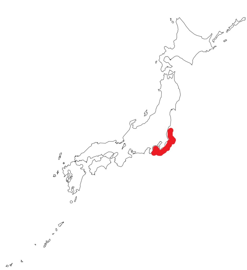
Tsunamis Occurring in the Kanto Region
The “Southern Kanto Earthquake” is a general term for M7-class major earthquakes that repeatedly occur in southern Kanto. Also known as the Capital Region Earthquake, Tokyo Earthquake, or Tokyo Great Earthquake, it is considered one of the greatest threats among urban earthquakes in Japan. The underground of southern Kanto is a region where multiple plates overlap complexly, making it one of the most seismically active areas in the world. While the epicenters are often inland, reducing the tsunami risk, large tsunamis are expected from earthquakes occurring off the coast of Ibaraki, east of Chiba, the Kuril Trench, the Japan Trench, and the Sagami Trough, making it a high-risk tsunami area.
The Great Kanto Earthquake (September 1, 1923) caused significant tsunami damage to the coastal areas of the Kanto region. This earthquake had a magnitude of 7.9, with its epicenter in the Sagami Trough in western Kanagawa Prefecture. The tsunami occurred immediately after the earthquake, reaching a maximum height of 12 meters in Atami City, Shizuoka Prefecture, and 9 meters in Tateyama City, Chiba Prefecture. The tsunami also significantly impacted Kamakura City, Kanagawa Prefecture, with waves exceeding 4 meters arriving just 11 minutes after the earthquake. Waves of 2 to 3 meters continued to hit the coast every few minutes, causing significant loss of life in coastal areas.
During the Great East Japan Earthquake in 2011, tsunamis also reached the Pacific side of Ibaraki and Chiba Prefectures. Additionally, changes in tidal levels were observed in Tokyo Bay, with reverse flow phenomena confirmed in rivers.
High-Risk Tsunami Areas
Ibaraki Prefecture/Chiba Prefecture/Tokyo/Kanagawa Prefecture/Shizuoka Prefecture
View of the Pacific Ocean from Katagai Beach, Katsuura City (Chiba Prefecture)
View of Tokyo Bay from Odaiba (Tokyo)
View of Tokyo Bay from Yokohama Minato Mirai (Kanagawa Prefecture)
View of the Shonan Coast from Enoshima and Shichirigahama (Kanagawa Prefecture)
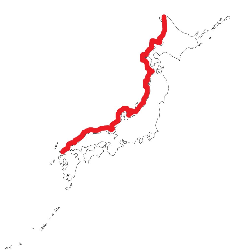
Tsunamis Occurring in the Sea of Japan
Although the Sea of Japan is considered to have relatively calm seismic activity, occasional large earthquakes can trigger tsunamis, causing significant damage to coastal areas. Tsunamis occurring in the Sea of Japan have several characteristics in terms of their generation mechanisms, propagation range, and affected areas.
The main sources of tsunamis in the Sea of Japan are active faults located along the eastern margin of the Sea of Japan and submarine landslides. These activities cause significant seabed changes, pushing up large masses of water and generating tsunamis.
In the 1983 Central Sea of Japan Earthquake, the tsunami affected a wide area from off the coast of the Oga Peninsula in Akita Prefecture. This earthquake and tsunami resulted in 104 fatalities, 100 of which were due to the tsunami. The lack of prior experience with earthquakes and tsunamis in this region, along with low preparedness and evacuation awareness, contributed to the extent of the damage.
The Southwest Hokkaido Earthquake on July 12, 1993, recorded a magnitude of 7.8, with its epicenter off the northwest coast of Okushiri Island. A tsunami occurred immediately after the earthquake, reaching Okushiri Island in just a few minutes. The tsunami height reached up to 30 meters in some places, causing extensive damage centered on Okushiri Island and resulting in the loss of 230 lives. The severity of the damage was influenced by the strong shaking of the earthquake and the rapid arrival of the tsunami.
In the Noto Peninsula Earthquake on January 1, 2024, tsunami inundation occurred in Suzu City, Noto Town, and Shika Town in Ishikawa Prefecture, close to the epicenter, with an inundation area reaching at least 190 hectares. The tsunami arrived very quickly after the earthquake, with some areas experiencing the tsunami within just 1-2 minutes.
The Sea of Japan coast, which is not densely populated, hosts many nuclear power plants, including the Tomari Nuclear Power Plant in Hokkaido, the Kashiwazaki-Kariwa Nuclear Power Plant in Niigata Prefecture, the Shika Nuclear Power Plant in Ishikawa Prefecture, the Tsuruga Nuclear Power Plant and Ohi Nuclear Power Plant in Fukui Prefecture, the Shimane Nuclear Power Plant in Shimane Prefecture, and the Genkai Nuclear Power Plant in Fukuoka Prefecture. The impact on these facilities during a tsunami is a significant concern, and ensuring their safety is an urgent issue.
Regions with High Tsunami Risk
Hokkaido/Aomori Prefecture (Sea of Japan side)/Akita Prefecture/Yamagata Prefecture/Niigata Prefecture/Toyama Prefecture/Ishikawa Prefecture/Fukui Prefecture/Kyoto Prefecture/Hyogo Prefecture (Sea of Japan side)/Tottori Prefecture/Shimane Prefecture/Yamaguchi Prefecture (Sea of Japan side)/Fukuoka Prefecture/Saga Prefecture
View of the Sea of Japan from Nabetsuru Rock on Okushiri Island (Hokkaido)
The 1993 Southwest Hokkaido Earthquake had its epicenter around 35 km underground near this island, leading to a rapid tsunami arrival and significant damage.
View of Ishikari Bay from Tenguyama in Otaru (Hokkaido)
View of the Sea of Japan from Akita Port (Akita Prefecture)
View of the Sea of Japan from Sakata Port (Yamagata Prefecture)
The live camera switches between Yamagata City and Sakata Port every hour.
View of the Sea of Japan from the mouth of the Shinano River (Niigata Prefecture)
View of the Sea of Japan from Himi City (Toyama Prefecture)
View of the Sea of Japan from Wajima on the Noto Peninsula (Ishikawa Prefecture)
The coastal area was affected by the tsunami during the Noto Peninsula Earthquake on January 1, 2024. Recovery activities can be seen on the live camera.
View of the Sea of Japan from Echizen Town (Fukui Prefecture)
View of the Sea of Japan from Fushino Coast in Tottori City (Tottori Prefecture)
View of the Sea of Japan from Oki Islands (Shimane Prefecture)
Saigo Port
View of the Sea of Japan from Tsunoshima Bridge (Yamaguchi Prefecture)
View of Genkai Sea from Hatsu Coast in Okagaki Town (Fukuoka Prefecture)
Tsunamis Generated by the Nankai Trough
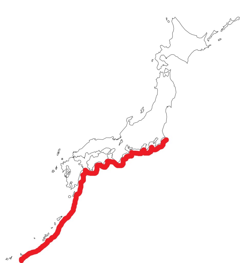
The Nankai Trough earthquake is a massive earthquake caused by the subduction of the Philippine Sea Plate beneath the Eurasian Plate. Based on its mechanism and past occurrences, it is predicted to cause extensive damage. In the Nankai Trough, the Philippine Sea Plate subducts beneath the Eurasian Plate at a rate of several centimeters per year. During this process, the plate boundary becomes locked, and strain gradually accumulates. When the strain reaches its limit, the plate boundary slips all at once, causing a massive earthquake.
A characteristic of the Nankai Trough earthquake is the potential for the three source regions, “Tokai,” “Tonankai,” and “Nankai,” to act in concert. If these source regions activate simultaneously, the earthquake’s magnitude is predicted to reach around 9. According to government estimates, if a maximum-class Nankai Trough earthquake occurs, areas from Shizuoka Prefecture to parts of Miyazaki Prefecture could experience seismic intensity 7, with surrounding areas experiencing intensity 6+ to 6-. Additionally, a massive tsunami exceeding 10 meters is expected to strike a wide area along the Pacific coast.
The Nankai Trough earthquake is predicted to have about a 70% chance of occurring within the next 30 years, making preparation for a massive earthquake and tsunami essential.
Past Nankai Trough Earthquakes
Hoei Earthquake (1707)
A massive earthquake estimated at magnitude 8.6 to 9.0 occurred, involving the three source regions of Tokai, Tonankai, and Nankai. It caused extensive damage, particularly in the Tokaido, Kii Peninsula, and Shikoku regions, with tsunamis exceeding 20 meters along the Kochi Prefecture coast, resulting in widespread catastrophic damage.
Ansei Earthquake (1854)
The Ansei Tokai and Ansei Nankai earthquakes occurred within 32 hours of each other. This earthquake also generated tsunamis exceeding 10 meters, resulting in many deaths and missing persons.
Showa Earthquake (1944 & 1946)
The Showa Tonankai and Showa Nankai earthquakes occurred about two years apart. The recovery was slow in some areas due to the post-war period.
Regions at High Risk of Tsunamis
Ibaraki/Chiba/Tokyo/Kanagawa/Shizuoka/Aichi/Mie/Osaka/Hyogo/Wakayama/Okayama/Hiroshima/Yamaguchi/Tokushima/Kagawa/Ehime/Kochi/Fukuoka/Oita/Miyazaki/Kagoshima/Okinawa
Izu Shirahama Beach (Shizuoka Prefecture)
Chubu Centrair International Airport (Aichi Prefecture)
The Ise Bay Typhoon, which made landfall on September 26, 1959, caused extensive damage, particularly in Aichi Prefecture, due to strong winds and storm surges. The disaster resulted in over 5,000 deaths and missing persons, making it one of the largest typhoon disasters in Japan’s history.
Minamiise Town (Mie Prefecture)
Tenjinzaki (Wakayama Prefecture)
Osaka Port (Osaka Prefecture)
Akashi Kaikyo Bridge (Hyogo Prefecture)
Miyajima Itsukushima Shrine (Hiroshima Prefecture)
Naruto Bridge (Tokushima Prefecture)
Seto Ohashi Bridge (Kagawa Prefecture)
Sanport Takamatsu (Kagawa Prefecture)
Chichibugahama Beach (Kagawa Prefecture)
Famous for its scenic views resembling the Uyuni Salt Flats in South America.
